World's most popular community & resource for hunting in Africa since 2007
Africa Hunting
Welcome to AfricaHunting.com
 Welcome to the most visited site in the world for hunting in Africa! Since 2007, AfricaHunting.com is the place to go for online discussion of all things related to hunting worldwide. Find everything you need to know to embark on an African hunting safari; get detailed planning information, connect with reputable hunting outfitters and service providers to avoid costly mistakes. Our friendly hunting community welcomes 442,000
visitors monthly with over 73,000 members and is a place for seasoned African hunters and those who dream of someday hunting in Africa. You can do research or interact and ask questions, share experiences or view hunting reports and over 110,000 photos and videos, plus access Deals & offers and Free hunts & giveaways.
Welcome to the most visited site in the world for hunting in Africa! Since 2007, AfricaHunting.com is the place to go for online discussion of all things related to hunting worldwide. Find everything you need to know to embark on an African hunting safari; get detailed planning information, connect with reputable hunting outfitters and service providers to avoid costly mistakes. Our friendly hunting community welcomes 442,000
visitors monthly with over 73,000 members and is a place for seasoned African hunters and those who dream of someday hunting in Africa. You can do research or interact and ask questions, share experiences or view hunting reports and over 110,000 photos and videos, plus access Deals & offers and Free hunts & giveaways.AfricaHunting.com is brought to you by our site Sponsors and is supported by our member Benefactors and Supporters.
I hope that you will find AfricaHunting.com a great place to spend time preparing for or dreaming about your future African hunting safari or reliving your last.
Jerome Philippe, Founder of AfricaHunting.com
Safari planning guide

Hunting reports
- ZIMBABWE: Elephant & Leopard In Zimbabwe - Cancellation Hunt Report
- ETHIOPIA: Northern Operations / Collect Africa / Dean Stobbs Safaris 2024
- SOUTH AFRICA: Third Hunting Safari With LJ HUNTING SAFARIS
- SOUTH AFRICA: Hunting With GAME 4 AFRICA SAFARIS In The Eastern Cape
- NAMIBIA: Namibia Hunt With Leopard Legend Hunting Safaris 2023
Deals & offers
Members online
- Fatback
- cperso
- saswart
- Warren Knudsen
- TwoTracks
- Pieter Oosthuizen
- gprippers
- davidg8480
- Joebliksem
- Hunter-Habib
- Sh1kar
- skydiver386
- rjb
- Beefeater
- hainew
- Frederik
- Rpshan
- KaKaTo
- matt85
- hva146
- kingfish0000
- SABENA1
- buckstix
- BillSpe
- grand veneur
- Sika98k
- AfricaHunting.com
- VertigoBE
- mark-hunter
- Fabnosh
- DieJager
- Tgood1
- FARO EAST NORTH CAMEROON
- MountKling
- rhoward252
- rifletuner
- Woodcarver
- Jäger_Ivo
- PerH
- Cgswimmer25
- JAHunts
- 375Fox
- RockSlinger404
- Houston Bill
- Dr Ray
- saniya838
- KuduW
- cm76
- V42
- CZDiesel
Forum statistics
Latest resources
-
 EPIC HUNTING SAFARISOUTH AFRICA - You tried the rest. Now come hunt with the best.
- EPIC HUNTING SAFARI
- Updated:
-
 MATTANJA HUNTING SAFARISSOUTH AFRICA - Every Safari a Success... Every Success a Trophy!
- MATTANJA HUNTING SAFARIS
- Updated:
-
 DERIAN KOEKEMOER SAFARISSOUTH AFRICA - Hunt the way it’s meant to be
- DERIAN KOEKEMOER SAFARIS
- Updated:
-

-
 HENRY GRIFFITHS SAFARISSOUTH AFRICA - Hunting in Southern Africa with HENRY GRIFFITHS SAFARIS
- HENRY GRIFFITHS SAFARIS
- Updated:
Media statistics
- Categories
- 25
- Uploaded media
- 122,792
- Embedded media
- 1,106
- Comments
- 15,286
- Disk usage
- 135.2 GB
Latest profile posts
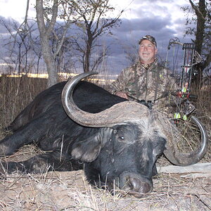
check out our Buff hunt deal!
 www.africahunting.com
Buffalo Hunt with Henry Griffiths Safaris $10000
Here with is our offer for a hunt of a...
Because of some clients having to move their dates I have 2 prime time slots open if anyone is interested to do a hunt
5-15 May
or 5-15 June is open!
shoot me a message for a good deal!
5-15 May
or 5-15 June is open!
shoot me a message for a good deal!